Mojave National Preserve lies between Interstates 15 and 40 east of Barstow, and most people pass it at highway speed. Turn off at Baker, Cima Road or Essex Road and the scale changes: 1.6 million acres, nearly 700,000 of them designated wilderness, crossed by a handful of paved roads and what the National Park Service calls hundreds of miles of unpaved ones.
It suits a self-contained vehicle. There is no entrance fee and no permit system for backcountry travel, roadside camping is allowed in previously used sites, and services are close to none. This guide sets out what the Park Service publishes about the roads, the vehicles they need, the camping rules and the hazards. For what is open today, use the preserve’s conditions page.
Why go
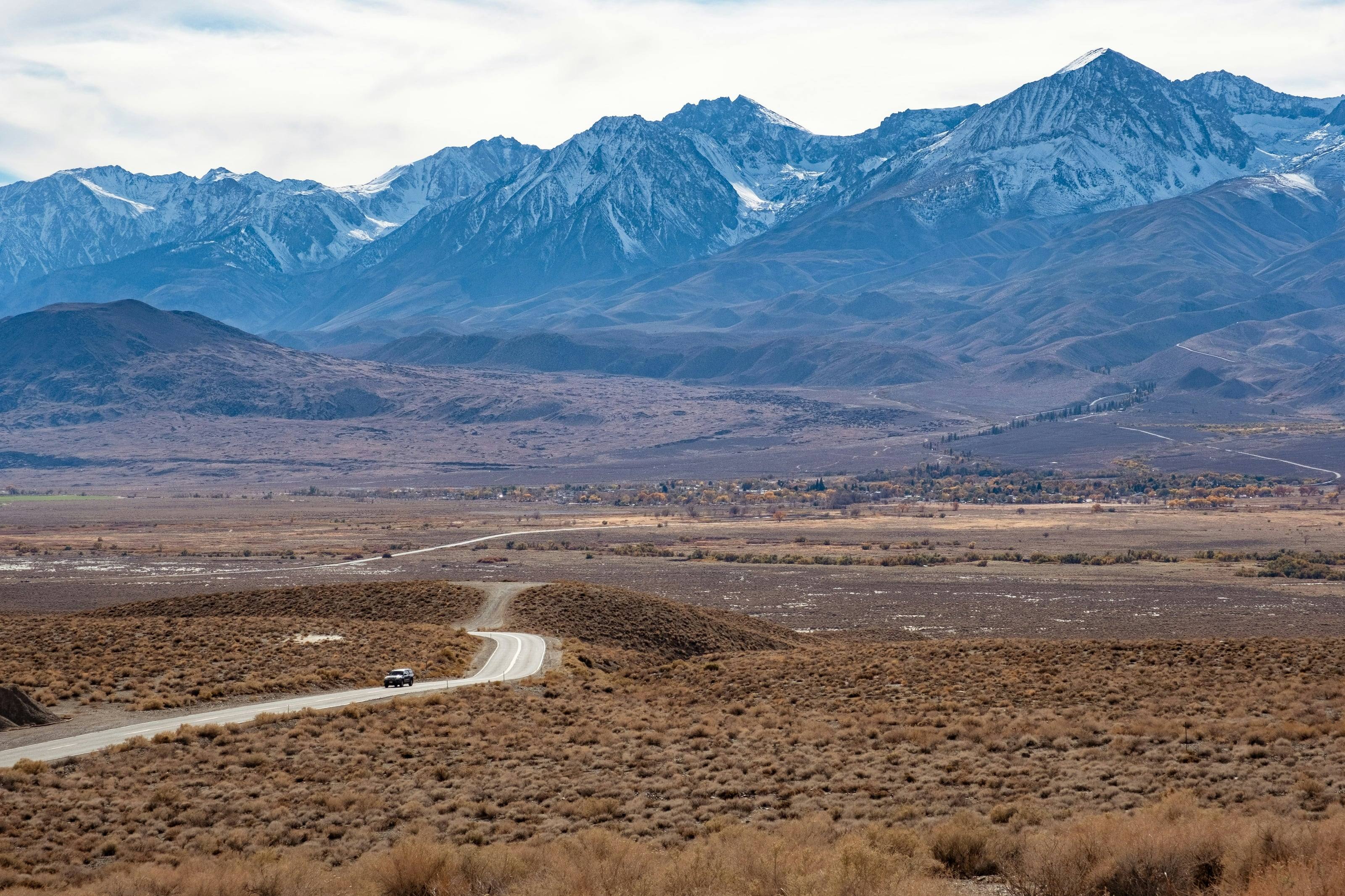
The preserve’s four-wheel-drive page makes the case in two sentences: there are hundreds of miles of unpaved roads to explore here, and they cross volcanic fields, Joshua tree woodland and mountain country with a long human history. The paved roads alone reach the Kelso Dunes, the restored Kelso Depot, the Joshua trees of Cima Dome and the cliffs of Hole-in-the-Wall. Dirt takes over from there, to the lava tube off Aiken Mine Road, the New York Mountains and the Mojave Road, the historic wagon route that crosses the whole preserve.
NPS is just as direct about the terms. Dirt roads are not regularly monitored or maintained, cell service is sporadic, and the advice is not to attempt rugged backcountry roads alone: a second vehicle lets you extricate each other.
Source 2
When to go
“The weather is generally most comfortable in the spring and fall,” says the preserve’s weather page. Temperatures over 100 degrees may begin as early as May, and many summer days are too hot for outdoor activities. Winter brings freezing temperatures and strong winds, the higher elevations typically receive some snow, and the sun can set as early as 4:30 pm.
Annual precipitation ranges from 3.5 inches at lower elevations to nearly 10 inches in the mountains. Most rain falls between November and April, the driest months are May and June, and summer thunderstorms, the monsoon, may bring sudden, heavy rainfall. The four-wheel-drive page is blunter. Spring and fall have the best temperatures and the biggest crowds, winter nights can drop below freezing, and “travel during the summer is not recommended.”
Source 3
The roads: paved, graded and four-wheel drive
NPS opens its road guide with the warning that not every road is suitable for standard passenger cars: “The majority of our off-pavement roads require high clearance and 4WD.” The paved network is small. Kelbaker Road runs 56 miles from Interstate 15 at Baker to Interstate 40. Cima Road is 18 paved miles from Interstate 15 to Cima. Essex Road is the paved way from Interstate 40 toward Hole-in-the-Wall, 10 miles to Black Canyon Road and 10 more to the campground.
Black Canyon Road is paved only between Essex Road and Hole-in-the-Wall Campground. Beyond it NPS calls the road passable to two-wheel drive but encourages those visitors to use paved roads whenever possible. Ivanpah Road (27 miles) and Lanfair Road (19 miles) are paved at the north and south ends, but “the middle 15 miles are rough, rocky dirt roads, that are not suitable for 2WD.” The 7-mile unpaved Aiken Mine Road reaches the Lava Tube, and the Mojave Road is listed simply as a high clearance four-wheel-drive route.
The camping page supplies the line that matters most: “No maintenance is performed on dirt roads in Mojave National Preserve.” Expect rough and narrow roads, no turnarounds and soft sand.
Source 1
What your vehicle needs
The preserve’s off-pavement guide starts here: “A high clearance 4x4 with tires designed for off-pavement use is the most important safety item you need.” By its definitions any factory stock full or mid-size 4x4 pickup or SUV is high clearance. Cars, minivans, RVs and many crossover SUVs are low clearance, and none of them is designed for preserve roads. All-wheel drive is not four-wheel drive with a transfer case, and may fail on a steep, loose climb.
Tires get the most attention. For full size vehicles NPS calls a good condition E-range all-terrain tire the ideal, asks for 3-ply sidewalls, and warns that mud-terrain tires pack solid with the local clay. Carry at least one all-terrain spare and consider two, because drivers sometimes tear the front and rear sidewalls on the same rock. Most rescues involve vehicles stuck in sand. Many drivers lower tire pressure to 20 psi on soft sand and refill at the pavement. Rental 4x4s often arrive on street tires, so read the sidewall.
The four-wheel-drive page sets the legal floor. Every vehicle must be street legal under California rules, with current registration, lights, turn signals and insurance. ATVs, UTVs and side-by-sides are not permitted, and California green sticker and red sticker registration is not recognized.
Recommended safety equipment (NPS)
- 01A return plan filed with a friend or relative.
- 02A shovel, and a jack with a base that works on rocky or sandy ground.
- 03An all-terrain spare tire, and a second spare.
- 04Extra food, water and any needed medications to last several days.
- 05Hot and cold weather clothing.
- 06A satellite phone or satellite messenger.
Do not skipFrom the four-wheel-drive page: off-pavement travel is only allowed on existing, open dirt roads. The rule against cross-country travel is strictly enforced, and driving in washes is not permitted.
Source 4
Camping: three campgrounds and the roadside rules
The developed campgrounds are Mid Hills, Hole-in-the-Wall and Black Canyon, the last for groups and riders with horses. NPS describes all three as year-round campgrounds with two-wheel-drive access, vault toilets, trash receptacles, fire rings and picnic tables. Mid Hills and Hole-in-the-Wall take up to 8 people per site and are reservation only. Water is available at Hole-in-the-Wall and Black Canyon; at Mid Hills you haul it in. Hole-in-the-Wall has the dump station. Mid Hills sits at 5,600 feet and Hole-in-the-Wall at 4,400 feet.
Roadside camping is for “well-prepared campers who are self-sufficient.” Most sites require a high clearance four-wheel-drive vehicle, there is a 14-day limit, and there is no fee. NPS publishes a table of roadside sites along Black Canyon, Cima and Kelbaker roads with GPS points and hazard notes, and advises drivers not to go beyond those points.
Roadside camping rules
- 01Use previously used sites only. Vehicles stay in previously disturbed areas, and creating new campsites is not allowed.
- 02Camp more than 200 yards from any natural or constructed water source.
- 03No camping within 1/4 mile of paved roads or of the Zzyzx access road, or within 1/2 mile of Fort Piute or Kelso Depot.
- 04None on the Kelso Dunes access road, its parking lot, the area north of the road to the crest of the dunes, or 1/4 mile south of it.
- 05Fires only in an existing fire ring or a fire pan. Bring firewood from outside the preserve: collecting or cutting it is prohibited.
- 06Pack out all trash and toilet paper. Bury human waste at least 6 inches deep.
- 07Groups of more than 7 vehicles or 25 people need a Special Use Permit.
Source 5
Fuel, water and services
Are there gas stations? The preserve’s FAQ answers “No,” and lists the nearest at Baker, Cima Road at Interstate 15, Primm, Searchlight, Fenner, Amboy and Ludlow. “Running out of gas is a common and expensive problem, so please fill up before you enter the Preserve!” The conditions page adds that there are no gas stations where Kelbaker Road meets Interstate 40. Confirm any station before you rely on it.
Water is nearly as scarce. The conditions page lists potable water at the Kelso Depot bathhouse, the Hole-in-the-Wall Visitor Center and Hole-in-the-Wall Campground, and says there are no other public water facilities in the preserve. The FAQ page is as brief on the rest: no food service, no lodging inside the preserve, and cell phone service that is sporadic and unreliable.
Source 7
Weather and hazards
Heat first. The safety page recommends a minimum of one gallon of water per person per day, two gallons for hikers and cyclists, and no strenuous activity in extreme heat.
The off-pavement guide lists the road hazards. During the summer monsoon, June to September, travel in the morning, because storms usually occur after 1 pm. Above 3,000 feet in winter, roads may be saturated from rain or snow and temperatures can drop well below freezing. This is ranch country, so expect cattle in the road, especially in the dark. If something goes wrong, “staying with your car is the most important thing you can do.” People have died from exposure trying to walk back to the paved roads.
Do not make camp in a dry wash: the camping regulations warn that flash floods develop quickly in the desert. On the road, remember the National Weather Service figures: 12 inches of rushing water can carry away most cars, and 2 feet can carry away SUVs and trucks.
Do not skipFrom the off-pavement guide: “Always assume the road will get worse ahead. If it gets too rough for you, turn around!”
Source 9
Permits and fees
“An entrance pass is not required to access Mojave National Preserve,” and passes are not sold inside it. The camping regulations state that there is no permit or registration system for backcountry travel and camping, and roadside sites are free and first come, first served. The family campgrounds at Mid Hills and Hole-in-the-Wall are reserved ahead. Groups of more than 7 vehicles or 25 people need a Special Use Permit, and NPS asks for up to a month to process it.
Source 10
Who to check with before you go
The Alerts and Conditions page lists the primary roads and a long table of backcountry roads, each with the vehicle it needs and notes on damage, and links to Caltrans, San Bernardino County and Nevada road information for the approaches. It states the standard plainly: many unimproved and backcountry roads require high clearance of 8 inches or more and four-wheel drive with a low range transfer case and heavy duty tires, and all-wheel-drive SUVs may not be appropriate.
The off-pavement guide admits that NPS cannot report conditions for every road in a preserve this size: expect poor conditions, and “don’t go if it looks bad or rain is forecast.” For information call (760) 252-6100 during business hours. The 24-hour emergency dispatch number is (702) 293-8998.
Source 8
Questions people ask
Is there gas in Mojave National Preserve?
No. NPS states that gas is not sold in the preserve and that there are no gas stations where Kelbaker Road meets Interstate 40. Its FAQ lists the nearest stations at Baker, Cima Road at Interstate 15, Primm, Searchlight, Fenner, Amboy and Ludlow. Confirm before you go and arrive with a full tank.
Can I camp anywhere along the dirt roads?
No. Roadside camping must be in previously used sites, more than 200 yards from any water source, at least 1/4 mile from paved roads and outside the posted or listed no-camping areas around Kelso Dunes, Zzyzx, Fort Piute and Kelso Depot. There is a 14-day limit and no fee.
Do I need four-wheel drive?
For the paved roads and the developed campgrounds, no. For most of the rest, yes: NPS says the majority of its off-pavement roads require high clearance and 4WD, and its conditions page specifies 8 inches or more of clearance, a low range transfer case and heavy duty tires for many backcountry roads.
Do I need a permit or an entrance pass?
Neither, for ordinary travel and camping. NPS does not require an entrance pass and has no permit or registration system for backcountry travel and camping. Groups of more than 7 vehicles or 25 people need a Special Use Permit.
Where can I fill water containers?
NPS lists potable water at the Kelso Depot bathhouse, the Hole-in-the-Wall Visitor Center and Hole-in-the-Wall Campground, and says there are no other public water facilities in the preserve. It recommends at least one gallon per person per day.
When is the best time to visit?
NPS says the weather is generally most comfortable in spring and fall. Temperatures over 100 degrees may begin as early as May, and its four-wheel-drive page says travel during the summer is not recommended.
 Bureau of Land Management (BLM)
 US Forest Service (USFS)
 National Park Service (NPS)
 US Fish and Wildlife (USFW)
 Bureau of Reclamation (USBR)
 Department Of Defense (DOD)
 Bureau of Indian Affairs (BIA)
 Other Federal
 State
 Local
 Alaska Native Lands (Patented or Interim Conveyed)
 Alaska Native Allotment
 Road
 Primitive Road
 Road
 Primitive Road
 Trail
 Roads open to all Vehicles, Yearlong
 Roads open to all Vehicles, Seasonal
 Roads open to highway legal vehicles only, Yearlong
 Roads open to highway legal vehicles only, Seasonal
 Special Designation, Yearlong
 Special Designation, Seasonal
 Trails open to all vehicles, Yearlong
 Trails open to all vehicles, Seasonal
 Trails open to vehicles 50" or less in width, Yearlong
 Trails open to vehicles 50" or less in width, Seasonal
 Trails open to motorcycles, Yearlong
 Trails open to motorcycles, Seasonal
 Special Designation, Seasonal
 Trails Open to Wheeled Vehicles Only < 50" in Width, Yearlong
 Trails Open to Wheeled Vehicles Only < 50" or Less in Width, Seasonal
 Wilderness Area
 Wilderness Study Area